May 11, 2022


Posted by Bilawal Sidhu, Senior Product Manager, Google Maps and Eric Lai, Group Product Manager, ARCore
ARCore, our AR developer platform, works across billions of devices, providing developers with simple yet powerful tools to build immersive experiences that seamlessly blend the digital and physical worlds.
In 2019, we launched the ARCore Cloud Anchors API for developers to anchor content to specific locations and design experiences that can be shared over time by multiple people across many different devices. Since then, we’ve been listening to developer feedback on how to make it easier to create and deploy AR experiences at scale.
Today, we’re taking a leap forward by launching the ARCore Geospatial API in ARCore SDKs for Android and iOS across all compatible ARCore-enabled devices. This API is available now at no cost to download and opens up nearly 15 years of our understanding of the world through Google Maps to help developers build AR experiences that are more immersive, richer and more useful.
The Geospatial API provides access to global localization — the same technology that has been powering Live View in Google Maps since 2019, providing people with helpful AR powered arrows and turn-by-turn directions. Based on the Visual Positioning Service (VPS) with tens of billions of images in Street View, developers can now anchor content by latitude, longitude and altitude in over 87 countries, without being there or having to scan the physical space, saving significant time and resources.
 |
| Using machine learning to compute a 3D point-cloud of the environment from Google Street View imagery |
For end users, discovering and interacting with AR is faster and more accurate as images from the scanned environment are instantaneously matched against our model of the world. This model is built using advanced machine-learning techniques, which extract trillions of 3D points from Street View images that are then used to compute the device position and orientation in less than a second. In other words, users can be anywhere Street View is available, and just by pointing their camera, their device understands exactly where it is, which way it is pointed and where the AR content should appear, almost immediately.
We’ve been working with early access partners like the NBA, Snap, Lyft, and more to explore and build applications for different industries, including education, entertainment and utility. For example, micro mobility companies Bird, Lime and WeMo are using the API to remove friction from parking e-scooters and e-bikes, adding pinpoint accuracy so riders know exactly when their vehicle is in a valid parking spot. Lime has been piloting the experience in London, Paris, Tel Aviv, Bordeaux, Madrid, and San Diego.
  |
| Bird (left) and Lime (right) use the ARCore Geospatial API to enable more precise location-based AR experiences |
Telstra and Accenture are using the API to help sports fans and concertgoers find their seats, concession stands and restrooms at Marvel Stadium in Melbourne, Australia. DOCOMO and Curiosity are building a new game that lets you fend off virtual dragons with robot-companions in front of iconic Tokyo landmarks.
  |
| Telstra and Accenture (left) and DOCOMO (right) use the ARCore Geospatial API to create new, entertaining AR experiences |
 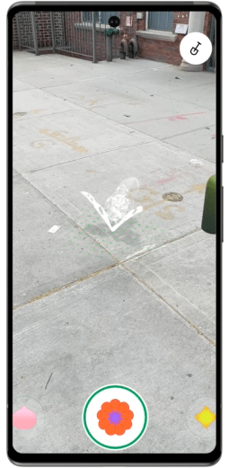 |
| Balloon Pop (left) and Pocket Garden (right) are open source demo apps that showcase the ARCore Geospatial API |
With the introduction of the ARCore Geospatial API we're providing the foundation for building world scale AR experiences. Get started today at g.co/ARCore. We’re excited to see what you create when the world is your canvas!


